BY Lee McClellan
FRANKFORT, Ky. – Cumberland Falls’ 68-foot drop is world famous as the “Niagara of the South.” Moonbeams reflecting off the mists from the falls create moonbows. The boulder-strewn riverbed left from the upstream migration of Cumberland Falls through the millennia makes some of the most challenging whitewater rapids in the South.

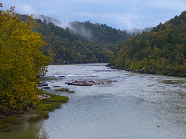
The section of the North Fork of Cumberland River from Cumberland Falls to Lake Cumberland gets all of the publicity; but the nearly 17-mile section of the river upstream of the falls remains relatively unknown by comparison. This is good news for paddlers who want serenity and enjoy an intimate gorge surrounded by the Daniel Boone National Forest while catching quality smallmouth bass.
Boaters have the option of two floats that showcase this unique and remote part of the Daniel Boone National Forest. The first covers about 11 miles, the second 5 miles. This stretch of water features shoals and mild whitewater rapids, perfect for a beginning paddler to hone their water-reading and paddling skills.
Water flow levels ranging from 500 to 1,100 cubic feet per second (cfs) make for the best paddling on this section of the Cumberland River. Paddlers may float this section at lower water levels, but will likely need to drag their boats over the shoals. Higher water levels up to 2,000 cfs make for challenging conditions for skilled paddlers only. Consult the “Cumberland River at Williamsburg” gauge to check flow levels at the Geological Survey’s website at waterdata.usgs.gov. Paddlers floating the Cumberland River or any stream must wear their personal floatation devices at all times while on the water.
The first float begins at the new Redbird Boat Ramp on KY 478, just past the KY 204 bridge over Cumberland River. Some older guide books and literature suggest launching on the north side of the KY 204 bridge, but this is no longer necessary.
About 3.5 miles into the float, Summer Shoals lies just downstream of the mouth of Jellico Creek that enters Cumberland River on the left (looking downstream). These shoals mark the beginning of the 16.1 mile section of the Cumberland River designated as a Kentucky Wild River. The designated stretch ends at the backwaters of Lake Cumberland.
The character of the Cumberland River changes dramatically about three more miles downstream when the river turns left into Bee Shoals. The bottom of the river morphs from a combination of mud and rock to bedrock. The rolling farmland upstream of Bee Shoals gives way to rockhouses towering above the paddler. The river picks up gradient and carves down into the sandstone bedrock of the Cumberland Plateau as it makes its descent toward Cumberland Falls.
Bee Shoals marks roughly the halfway point of this float. Float campers utilize the banks downstream of Bee Shoals as camping sites.
Crow Shoals awaits paddlers a little over a mile downstream from Bee Shoals. Long Bottom lies just downstream after the river bends to the left. Forest Service Road 536 (also known as Long Bottom Road on some maps and Long Branch-Oak Ridge Road on county maps) runs to Long Bottom and can make a take-out or put-in spot. Long Bottom Access lies 9 miles downstream from Redbird Boat Ramp.
The last section of Forest Service Road 536 down to Cumberland River is extremely rugged and recommended for high clearance four-wheel drive vehicles only.
Marsh Creek meets the Cumberland River across from Long Bottom Access and marks the beginning of Long Branch (also known as Indian Creek) Shoals. Some maps denote another access at the end of Mouth of Indian Creek Road (also known as Sand Hill Road and Horne Cabin Road), but this road is extremely rough and nearly impassable at times.
A little more than a mile downstream, the Cumberland flows to the left around McKee Bend and over Thunderstruck Shoals, an ancient river crossing used by Native Americans for centuries.
The take-out at the end of Thunderstruck Road (also called Singleton Road) lies on the left. Once a paddler flows over Thunderstruck Shoals, they need to pay close attention as the Thunderstruck Access is easy to miss. A large boulder juts out from the water just downstream of this access and makes a good landmark for paddlers. Limited parking exists here, however.
The next float begins at Thunderstruck Access and ends at the Cumberland Falls State Resort Park. This float is the best choice for anglers. They may take their time fishing with an easy shuttle from Cumberland Falls State Resort Park to Thunderstruck Access (via KY 90 and KY 700).
The Pitch Rapids greets paddlers just downstream of Thunderstruck Access. At high water, these rapids approach Class II in difficulty and should be run on the center-left for the first drop, then moving to the right for the second. At normal water levels, these rapids are fun for all levels of paddlers.
Just downstream from the Pitch Rapids lies Slick Shoals. At Slick Shoals, the river enters into a deeper gorge that lasts all the way until the headwaters of Lake Cumberland. Exceptional scenery surrounds paddlers in this stretch of river.
Downstream from Slick Shoals the Cumberland flows hard left around Blue Bend. The impressive stone-arched KY 90 bridge (also known as Gatliff Bridge) comes into view just after Blue Bend.
Several stream drops lie between Blue Bend and the bridge. Once boaters clear the last of these drops, paddlers must work to the right of the river. An upset or problem of any kind creates a treacherous situation as the rapids leading to Cumberland Falls may pull the boater over the 68-foot drop of the falls.
The take-out is just downstream of the KY 90 bridge at the parking lot for viewing Cumberland Falls.
Fishing this section of Cumberland River is an unusual experience in comparison to most Kentucky smallmouth streams. After clearing Summer Shoals, the river widens to nearly two football fields. The usual water reading and lure placement goes out the window when fishing a river this wide.
The shoals run bank to bank as well. The flowing water at the head of these shoals along with eddies and plunge holes at the end of them present the highest percentage spots for smallmouth bass on the river. The Cumberland flows strong in this stretch, even at low water. Therefore, anglers should use jigs and leadheads ranging from 3/16-ounce to 3/8-ounce. Lures this heavy would constantly hang up on the bottom in most Kentucky smallmouth streams.
Target these areas with black or motor oil-colored double-tailed skirted grubs rigged on 3/16-ounce leadheads. Use heavier heads if the lures fail to touch bottom occasionally. Black jigs tipped with black crawfish-shaped trailers also work well. Black is a strong color choice for Cumberland River smallmouth.
The river often flows with some color to the water, so these lures work in either slightly stained or clear water. Deep running brown and chartreuse crankbaits and white spinnerbaits with Colorado blades work well in stained water. Local anglers use soft-plastic leech imitations rigged on leadheads for smallmouths.
This stretch of the river often flows over long expanses of bedrock, especially the lower 5-mile stretch from Thunderstruck Shoals to Cumberland Falls State Resort Park. Anglers should work their lures along ledges and larger cracks in the bedrock, often right in the middle of the river. This is an excellent presentation for the larger smallmouth bass, as most anglers don’t fish these spots.
Sheltowee Trace Outfitters offers canoe rentals and shuttle services on the Cumberland River. Cumberland Falls State Resort Park has excellent accommodations in the DuPont Lodge and cottages for rent. Paddlers may take an interesting side trip to Eagle Falls via a 1.5 mile trail just across the KY 90 bridge on the right.
Sheltowee Trace Outfitters:
1-800-541-RAFT (7238)
Cumberland Falls State Resort Park:
1-800-325-0063
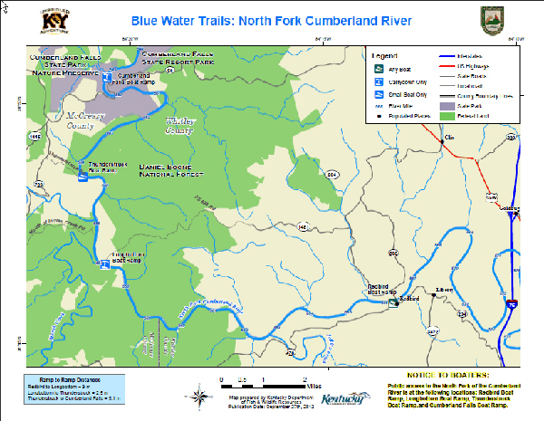
The Blue Water Trails series supports Gov. Steve Beshear’s Adventure Tourism Initiative. Log on to Kentucky Fish and Wildlife’s Blue Water Trails webpage at fw.ky.gov for a detailed map.
Media Contact: Lee McClellan 1-800-858-1549, ext. 4443


Be the first to comment