By Lee McClellan

FRANKFORT, Ky. – The rolling Pennyroyal country south of the Green River looks like a pockmarked World War I battlefield from the air. Those pockmarks aren’t from artillery shells impacting the ground; they come from a combination of rainfall, porous limestone and time.
These forces created sinkholes that collect rainfall and power underground streams that course strongly with each storm. The streams eventually flow north to the Green River and emerge from the ground as springs such as Echo River Spring, River Styx Spring and Turnhole Spring.
During the water’s travel from sinkhole to Green River over the millenia, it carved tunnels, caverns and huge rooms through the porous, easily dissolved limestone under the ridges along the south side of the river. These features seemed so gargantuan to the first visitors they called it Mammoth Cave, now recognized as the longest cave system in the world.
Canoeists and kayakers may float the Green River right through the heart of Mammoth Cave National Park and witness one of the most unique geological areas on Earth. Mammoth Cave National Park is a World Heritage Site and Biosphere Reserve – recognition of the ecosystem’s international importance.
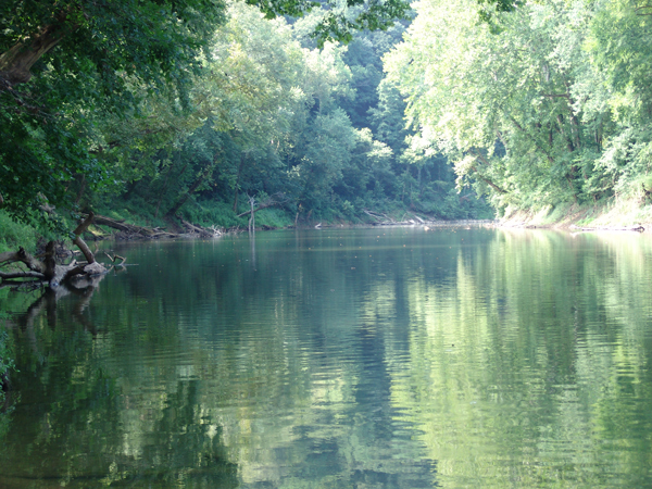
Two floats through the park give paddlers an intimate experience with the power of flowing water and nature. The dark cyan waters of the Green River flow through a bluff-lined gorge with streamside caves, springs and healthy populations of black bass, sunfish, catfish and toothy muskellunge. The flow of Green River makes for an easy, relaxing float, perfect for families, beginners and anglers.
This stretch of Green River is floatable year-round, but the National Park Service warns paddlers not to float the river at the 10 foot level or higher. The park service maintains a phone line at (270)-758-2166 for current river levels and information on the Green River Ferry and Houchins Ferry. Paddlers must mind the operation of these ferries while floating and land their boats on the downstream side of the ferry landing.
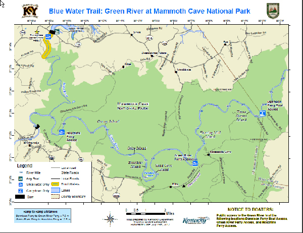
The first float begins at the historic Dennison Ferry Access and Day Use Area on Dennison Ferry Road (some maps refer to this road as Big Woods Road) and ends at the Green River Ferry. The gravel access road will test the limits of smaller cars, but is passable. Dennison Ferry requires a fairly steep carry-down to the water. The park service provides wooden slides on the stairs for canoes and kayaks, but secure all gear beforehand or it may wind up floating downriver.
A streamside cave greets paddlers on the left (looking downstream) a short way into this float that boaters may paddle into for about 40 feet at certain water levels. The shoals and gentle riffles hold smallmouth bass on this stretch. The chute to the right of Three Sisters Island, about a mile into the float, is a good spot to throw a 1/8-ounce tube jig in the green pumpkin color. A crawfish-colored medium-running crankbait retrieved along the bottom also produces strikes.
The entrance to the famous Crystal Cave lies on the ridge above the floaters on the left, just before Three Sisters Island. The renowned cave explorer Floyd Collins discovered this cave in 1917. He later grew internationally famous for surviving for 14 days after getting stuck while exploring the unstable Sand Cave in 1925. After valiant efforts to rescue Collins, he succumbed to thirst, exposure and starvation. The media attention drove public awareness of the Mammoth Cave area and served as a catalyst for the creation of Mammoth Cave National Park in 1926.
The river eventually flows around a left-hand bend. The rocky outside bank holds smallmouth bass. After the bend, the Green flows over some good shoals that also hold smallmouths.
Spotted and largemouth bass lurk in the woody cover of the slower moving sections of this float. Four-inch black finesse worms rigged on 1/8-ounce leadheads probed through the wood draws strikes.
The river then bends to the right at the base of the ridge that holds the entrance to the Great Onyx Cave. Some islands also punctuate this stretch and make good places to prospect for smallmouth bass in the flowing chutes, especially one of the largest, Floating Mill Island.
After a bend downstream, paddlers float near the Historic Entrance to Mammoth Cave. The take-out at Green River Ferry lies on the left less than a mile later. It is a short carry to the parking lot at Green River Ferry.
The next float covers 12 miles, beginning at Green River Ferry and ending at Houchins Ferry. This float requires a lengthy shuttle, but boaters can save some time by taking the gravel Joppa Ridge Road which lies on the right a short distance from Green River Ferry. This road is one-way from Green River Ferry Road to KY 70 (Brownsville Road), so it can’t be used on the return from Houchins Ferry.
Paddlers will notice the Green River grows deeper and more sluggish from the influence of Lock and Dam No. 6 downstream of Mammoth Cave National Park. The river takes a long, slow bend around the end of Joppa Ridge and the deeper woody cover in this stretch holds muskellunge. Anglers with bass fishing tackle can catch Green River muskellunge, provided they use a wire leader on the end of their lines to attach a lure. Monofilament, fluorocarbon and even braided lines are no match for the teeth of a sizeable muskellunge.
The stretch of Green River in Mammoth Cave National Park produced several state record muskellunge in the 1950s and 1960s. Medium-running crankbaits in fire tiger, gold or chrome draw muskellunge strikes as do large white double-bladed spinnerbaits. The treble hooks of the traditional muskie in-line spinners dressed in bucktail often get hung up in woody cover.
After flowing around Joppa Ridge, the river makes a horseshoe-shaped bend to the south called Turnhole Bend, named for Turnhole Spring. The small lake created by this spring provided steamboats a place to turn around back in the day.
The two islands in Turnhole Bend, Sand Cave Island and Boardcut Island, are popular spots for float camping. Campers must obtain a free backcountry permit from the park’s Visitor Center. Check the weather forecast, as the Green rises quickly after rains. The National Weather Service provides a forecast on the radio at 530 AM on the dial.
The river straightens and passes Stice Island before bending to the left with Crump Island in the middle, just past the confluence with Buffalo Creek. The take-out is on the left at Houchins Ferry. The park service also operates a nice camping area at Houchins Ferry. Do not float past Houchins Ferry into Brownsville as the dangerous low-head dam at Lock and Dam No. 6 lies just upstream of the city.
Those who want a remote float may paddle the last 7 miles of Nolin River downstream of Nolin River Lake. The put-in is at the Tailwater Recreation Area off KY 732 via KY 259 from Brownsville, with the take-out at Houchins Ferry. Stunning rock cliffs and other formations await paddlers in this stretch with good fishing for spotted and largemouth bass. The first few miles downstream of the dam offer trout fishing as well.
Boaters will likely not encounter another soul on this float. Paddlers must work back upstream for nearly 2 miles to Houchins Ferry after the Nolin empties into the Green.
Visitors may enjoy a day of floating and a day of exploring the wonders of Mammoth Cave for an affordable and relaxing weekend getaway. The Mammoth Cave Hotel offers rooms and rustic cabins for rent as well as a camp store for supplies. Nearby Cave City and Park City offer accommodations as well.
Several canoe and kayak liveries operate in the park and offer boats for rent and boat shuttles.

Big Buffalo Crossing Canoe and Kayak:
(866)-233-2690
Green River Canoeing:
(270)-773-5712
Cave Country Canoe:
(270)-773-5552
Mammoth Cave Canoe and Kayak
(877)-59-CANOE
For accommodations and tour information:
Mammoth Cave National Park:
(270)-758-2180
Mammoth Cave Hotel:
(270)-758-2225
Cave City Convention Center:
(800)-346-8908
The Blue Water Trails series supports Gov. Steve Beshear’s Adventure Tourism Initiative. Log on to Kentucky Fish and Wildlife’s Blue Water Trails webpage at fw.ky.gov for a detailed map.
Author Lee McClellan is an award-winning associate editor for Kentucky Afield magazine, the official publication of the Kentucky Department of Fish and Wildlife Resources. He is a life-long hunter and angler, with a passion for smallmouth bass fishing.
Media Contact: Lee McClellan 1-800-858-1549, ext. 4443


Be the first to comment