Aug. 25, 2011
Author Lee McClellan
(This article is the tenth in the periodic Blue Water Trails series highlighting the floating, fishing and tourism opportunities on Kentucky’s streams and rivers).
FRANKFORT, Ky. – As the Cumberland River flowed off the Cumberland Escarpment just upstream of Burnside when the Earth was much younger, it made a spectacular waterfall. Over time, the mighty Cumberland’s flow cut back under the edge of the resistant sandstone of the escarpment until the rock wore too thin and collapsed into the river bed below it, creating a new falls.

The Cumberland River continued to chew its way upstream over thousands of years by this process, leaving behind a jagged, deep and incredibly scenic river valley that now makes one of the best whitewater floats in the upper South. At the head of this valley lies world-renowned Cumberland Falls, one of the largest waterfalls east of the Mississippi River. The Cumberland River falls off massive ledges of ancient sandstone to the river 68 feet below and during late winter and spring’s high flows and 55 feet below in the low water of summer and fall. Moonbeams reflect in the mists rising from the falls generate moonbows during bright moon periods of clear skies.
The building-sized boulders that line the riverbed and shore are the debris left by the headward erosion of the mighty Cumberland Falls. The pristine nature of the 16.1 mile section of the river from Summer Shoals, downstream to the headwaters of Lake Cumberland, compelled the Kentucky legislature to designate this stretch as a Kentucky Wild River.
Two floats for paddlers exist on this section of the river: one a whitewater run as tough as any in the country and a mild flatwater float ideal for beginners, families and fishing.
The rough riverbed and a drop of 11 feet per mile make for some of the most challenging rapids in the eastern United States on the first 10.5-mile section downstream of Cumberland Falls. Only experienced paddlers should attempt this run as some rapids approach Class IV whitewater at higher water levels and are a solid Class III during low water.
Water levels from 250 to 3,500 cubic feet per second (cfs) make the best floating conditions, although experts make this run at higher water levels. On the internet, log onto U.S. Geological Survey’s website at waterdata.usgs.gov and consult the “Cumberland River at Williamsburg” gauge.
Whitewater kayaks are recommended for this float and paddlers must wear helmets and personal floatation devices. The first float begins with a long carry from the parking lot just downstream from Cumberland Falls to a beach along the shore. Boaters often paddle back upstream to get an awesome view of the falls. Stay at least 100 yards away as a wicked reverse current will try to pull you into the falls, similar to the dangers downstream of a low-head dam.
The first rapids are Class II and lively, beginning with a drop paddlers call “Initiation” about one-half mile into the float. Run this one in the middle. Some lively, but manageable rapids greet paddlers until reaching Center Rock Rapid. Center Rock looks like a huge dinosaur laid down and died in middle of the river and this obstruction makes for a potentially dangerous rapid and requires prior scouting. The middle is the best line for the top of this two-tiered drop. Boaters either ride the pillow off the right side of Center Rock or angle the bow to catch the right hand eddy at the bottom of the drop, just past the rock.
The river settles into a stretch of pools followed by boulder gardens and Class II drops. The first of these drops is known as Bradford’s Rock about 2.5 miles into the float and should be run on the right at low water while most lines are good at higher water. Dog Slaughter Shoals follows a rapid known to paddlers as Willie Nelson’s. It lies just after the Cumberland’s confluence with Dog Slaughter Creek on the right, roughly 3.5 miles into the run.
Just downstream of Dog Slaughter Shoals, lies a river-wide drop known as Surfing Rapid, or Lunchstop. Surfing Rapid is a popular place to eat lunch and surf the standing wave with a kayak.
A Class III rapid known as Pinball follows Surfing Rapid and should be run in the middle right at low to moderate water levels. At higher water, floaters should avoid the hazardous rocks along the sides of the river that can pin a boat. A kayak will pick up a lot of speed in this intense rapid and paddlers need keep their boat straight.
Screaming Right Hand Rapid awaits roughly ¼-mile downstream of Pinball. Lake Cumberland’s headwaters smother this rapid when the lake level is at or above 705 feet above sea level.
The current drawdown of the Lake Cumberland due to ongoing repairs at Wolf Creek Dam puts the remaining rapids in play for longer stretches of the year than before the repair work began.
Screaming Right Hand Rapid starts with a significant drop over a ledge and then splashes onto a rock that forces the flow hard right. Paddlers can use the pillow of water off the rock to turn the boat. This dangerous rapid should be scouted at all water levels.
The Stair Steps lie in wait for a paddler about three-quarters of a mile downstream. This drop is a series of standing waves that kayakers should punch through in the middle of the river.
One of the hardest rapids on the float is the last, known as Last Drop. Paddlers must scout this rapid. Last Drop becomes a scary Class IV to Class V rapid at high water and should be portaged on the right.
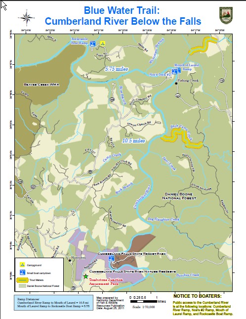
The last three miles are mild water with one Class II rapid at Bark Camp Creek Shoals when the lake level is below 690 feet. This section is pretty, but can take several hours to paddle at low water levels. The Cumberland Below the Falls is an exhausting float and local outfitters offer tows for this section in season. The take-out is the Mouth of Laurel Boat Ramp on the right (known as Noe’s Dock to locals).
The next float is a calm, 5.75-mile flatwater float through the headwaters of Lake Cumberland from the Mouth of Laurel Boat Ramp (via KY 1277 off U.S. 25 in Whitley County) to the Rockcastle Boat Ramp at the mouth of Rockcastle River (via KY 192 to KY 1193 to KY 3497 in Laurel County.) This section ideally suits a family on vacation or those wanting to fish more than navigate whitewater.
This stretch of water in the 1950s and 1960s produced native walleye up to 20 pounds during the regionally famous spring spawning runs. Walleye still run during early spring in this section of the Lake Cumberland headwaters, but anglers may encounter one in other times of year by fishing a medium depth banana-shaped crankbait along points in the mouth of tributary streams. Walleye also suspend in summer and fall over mud flats in this section of the river. A spinner rig tipped with a nightcrawler drug slowly across these flats produces walleye.
Smallmouth bass inhabit this water as well. Rocky outside bends of the river hold smallmouth bass year round. A 3/16-ounce small green pumpkin jig with hues of orange and purple fished slowly in this rocky structure should fool smallmouth. Points formed by tributaries meeting the lake are also productive areas for smallmouth bass on this float.
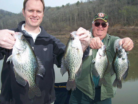
Spotted, or Kentucky, bass abound in this stretch of water. Black 4-inch finesse worms worked through any downed tree top or brush generates strikes. Minnows fished in these woody structures entice spotted bass as well as the surprisingly large black crappie that live in this section of the Lake Cumberland headwaters.
Sawyer Recreation Area lies about half way through this float on the south (left) side of the Cumberland and offers restrooms and picnic areas.
Bark Camp Creek, just north of the Cumberland Falls State Resort Park, offers good rainbow and brown trout fishing in a remote mountain environment. The Laurel River tailwater also holds trout.
Sheltowee Trace Outfitters offers guided floats and shuttle services. Cumberland Falls State Resort Park arranges rafting trips below the falls from May to October.
Cumberland Falls State Resort Park has excellent accommodations in the DuPont Lodge and cottages for rent. The Riverview Restaurant offers stunning views of the Cumberland River and good food from local sources. The Rockcastle Campground near the Rockcastle Boat Ramp offers tent camping.
The Blue Water Trails series supports Gov. Steve Beshear’s Adventure Tourism Initiative. Log on to Kentucky Fish and Wildlife’s Blue Water Trails webpage at fw.ky.gov for a detailed map.

Sheltowee Trace Outfitters:
1-800-541-7238
Cumberland Falls State Resort Park:
1-800-325-0063
Author Lee McClellan is an award-winning associate editor for Kentucky Afield magazine, the official publication of the Kentucky Department of Fish and Wildlife Resources. He is a life-long hunter and angler, with a passion for smallmouth bass fishing.
-30-
Contact: Lee McClellan
1-800-858-1549, ext. 4443
The Kentucky Department of Fish and Wildlife Resources manages, regulates, enforces and promotes responsible use of all fish and wildlife species, their habitats, public wildlife areas and waterways for the benefit of those resources and for public enjoyment. Kentucky Fish and Wildlife is an agency of the Tourism, Arts and Heritage Cabinet. For more information on the department, visit our website at fw.ky.gov.


Be the first to comment