(This article is the eleventh in the periodic Blue Water Trails series highlighting the floating, fishing and tourism opportunities on Kentucky’s streams and rivers).
By Lee McClellan
FRANKFORT, Ky. – It is hard to believe that waves of seawater once broke upon and submerged the Jackson Purchase region of Kentucky, west of the Tennessee River. Disbelief subsides once you view Clarks River National Wildlife Refuge, an area of sloughs and swamps rimmed with bald cypress, resembling Louisiana more than anywhere in Kentucky. The Jackson Purchase was at the northeastern corner of the Gulf of Mexico millions of years ago.

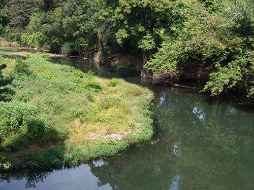
The Clarks River, named for George Rogers Clark, meanders back and forth through this low country of thick alluvial soils, creating unique untamed bottomland hardwood habitat. The dwindling amount of wetlands prompted the U.S. Fish and Wildlife Service to establish the Clarks River National Wildlife Refuge, the only one located solely within Kentucky’s borders. Clarks River also escaped the ravages of channelization, making it one of the few streams in the region left in its natural state.
Fall is one of the best times to visit this incredible resource as you can combine the fall colors with paddling, fishing and viewing of rare birds or migrating waterfowl. Fall’s frost also knocks back some of the undergrowth and puts an end to mosquito bites and chiggers.
The water levels in fall also make the best and safest paddling. The Clarks River drainage resembles a large funnel with many tributaries in the Murray area feeding a relatively narrow and small river. This makes the Clarks River jumpy, going from a placid calm river to a torrent of chocolate milk after a good rain. Check the U.S. Geological Survey streamflow website at waterdata.usgs.gov and click on the “Clarks River at Almo, KY” tab. You can check the flow graphs to see if the river is stable or rising. Stay off the Clarks River if the graphs show the river above its normal average flow; many dangerous deadfalls can trap a canoe or kayak.
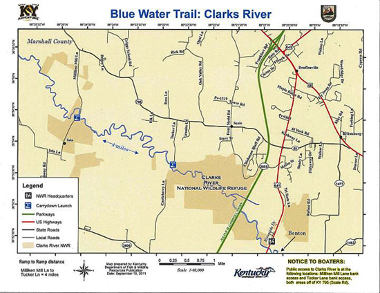
The heart of the refuge along the East Fork of Clarks River has the best public access for canoeists and kayakers. Only the most intrepid and fit paddlers should try the four mile stretch of the East Fork between Tucker Lane and Milliken Mill Lane. The refuge manager warns this will be an arduous task due to the number of deadfalls in the river. Paddlers attempting this float must portage many logjams, but will also get an intimate knowledge of a bottomland hardwood ecosystem.
The put-in for this section is at the end of Tucker Lane via KY 795 (also known as Scale Road). The take-out is at the bridge over the East Fork on Milliken Mill Lane, also off KY 795. Visitors may use a small parking area on the left, just after crossing the bridge. Look for the distinctive dark-stained wood crossties of the bridge. The take-out lies on the left just before the bridge.
A paddler will soon encounter the Buckholder Deadening, a 1,000-acre seasonal bottomland hardwood wetland south of the East Fork. Seasonal flooding limits the undergrowth in the area and leaves the floor of the woods relatively open, allowing you to see a long way. The Buckholder Deadening gives the visitor a brief glimpse of what our pioneer ancestors saw when they first came to the Jackson Purchase.
A much easier and better alternative to attempting the 4-mile float is paddling during low water, either upstream or downstream, and then returning to these access points. These two spots offer relatively easy paddling, along with productive fishing.
The East Fork of Clarks River runs deep at the Tucker Lane access and makes good habitat for largemouth and spotted bass as well as bluegill.
Largemouth bass hit shallow-running crankbaits with a square bill in the firetiger color. These lures draw fish from the many downed trees, root wads and sunken logs while not getting hung up in them. A snake-imitating lure worked near root wads and fallen trees may draw the biggest largemouth bass in the East Fork.
Spotted bass hang near woody cover and inhale 4-inch black finesse worms cast gently into fallen trees. They also hit black 3-inch curly-tailed grubs and small shallow-running chrome crankbaits worked along sunken logs.
Bluegill strike 1 ½-inch yellow, chartreuse or white curly-tailed grubs rigged on 1/32-ounce leadheads. Cast these lures into brush, along undercut banks or deadfalls. A sponge spider or small popper cast on a lightweight fly rod makes great sport, but the canopy in this section means fly anglers must employ a roll cast to keep from snapping off their poppers in the trees.
The section of the East Fork near Milliken Mill Lane runs shallower with more deadfalls and steeper banks, but offers good fishing in the deeper holes. Wading and shore-bound anglers can access the river in its upper reaches just outside of Benton via KY 408 and KY 1445 (Dogtown Road.) Excellent spotted bass fishing abounds in this stretch of the East Fork.
The section of the Clarks River National Wildlife Refuge on KY 408 holds the Environmental Education and Recreation Area with a 3-acre handicap-accessible fishing lake. Interpretive hiking trails course through native grass stands, managed wetlands and bottomland hardwood forest restoration sites. This area also offers fishing access to the East Fork of Clarks River.

Paddlers who enjoy bird watching will appreciate the Clarks River National Wildlife Refuge in fall. Rare warblers, thrushes and other songbirds can be seen along with raptors and migrating waterfowl.
Kentucky Dam Village State Resort Park offers excellent accommodations a short drive from the refuge. Visitors can combine paddling on the refuge with floating and paddling on scenic Kentucky Lake.
The Blue Water Trails series supports Gov. Steve Beshear’s Adventure Tourism Initiative. Log on to Kentucky Fish and Wildlife’s Blue Water Trails webpage at fw.ky.gov for a detailed map.
Kentucky Dam Village State Resort Park:
1-270-362-4271
Media Contact: Lee McClellan 1-800-858-1549, ext. 4443


Be the first to comment